
A History of Preston in Hertfordshire
Did a Roman road pass through Preston?
Introducing this subject, the book Roman Remains in Welwyn and Neighbourhood states that it had
been well-known for a long time that Welwyn and its environs had been occupied by the Romans - the
proof being the continual discovery of Roman coins, burial urns and buildings in the district.
Enlarging on this statement, The Hertfordshire Mercury of March 1904 included this comment:

The article continued, ‘It is believed that another of these Romanised British ways commenced on the
line of Ermine Street, near Ware…ran on to Hertford….then it went along the North Road to just
beyond the Hertford General Infirmary…From this spot such a way as this can be traced almost
continuously by roads and footpaths (for many of the footpaths are often much older than the
contiguous roads) onward for several miles….(through) Tewin…the south side of Knebworth Park and
by Graffridge Wood, then on to St Pauls Walden Church, Hitch Wood and the south-west side of
Temple Dinsley, and so by Hunsden House (aka Castle Farm) and Offley Holes to a point two miles
west of Hitchin; here it crossed the Icknield Way half a mile east of Highdown and so on to the west of
Pirton Church to Apsley End…’
It was also reported that, ‘from Potters Heath there runs a direct pathway to Codicote Heath (which is
said to have been a Roman camp). From the Heath there is a an old lane running westward to
Kimpton Mill….and so by an easy journey to Luton, by Peters Green…partly by road and partly by
footpath.’
Interestingly, in view of Preston’s location and topography (comments about which have been made
on this website) the article continued, ‘Thus it will be perceived that although the Romans had no way
in this district of their own providing, yet there was an open British track of sufficient dimensions to
suit their purposes; it also ran along fairly high and dry ground and not too far from the water, which
was a matter they were always careful to secure’.
Tales of Roman roads
Most will have heard tales of Roman roads - of how
they ran straight as an arrow for miles, and how
there is a Roman road at such-and-such a place. But
these commonly-held beliefs should be examined.
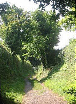
Near my wife’s childhood home at Pontypool,
Monmouthshire there is a way that locals call “The
Roman Road”. It drops from a height of around
1,000 feet to the Monmouthshire and Brecon Canal.
Even today there are clearly-visible large and
rounded stones that formed its surface (its
‘metalling’, which has always struck me as a curious
term) and the occasional curb which is treacherous
for the walker - in fact, the whole way is treacherous
in a wet day, of which there are many at Pontypool.
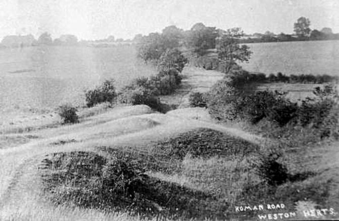
The “Roman road” near Pontypool, Mon
Moreover, in 2004 there was an assessment of “Roman roads in South Wales” by the Glamorgan-
Gwent Archaeological Trust. It endorsed several routes as being Roman roads, but Appendix 1 listed
Roads in OS files for which there is insufficient evidence to map and Appendix 2, PRNs for isolated
sightings of possible Roman roads and rejected sites. There were sixteen ‘roads’ in these
appendices. They had comments such as ‘Neither has any certain evidence and the alignments are
not particularly compelling’; ‘exhibiting no signs of Roman origin and more likely to be medieval’ and
‘others appear to be entirely conjectural’.
So, the assertion in 1904 that there was a Roman road that passed through Preston might be viewed
with some scepticism - especially as I have found no other reference to its existence.
Re: Roman roads (or viae)
When the Romans first invaded England, they had no choice but to advance using the existing track-
ways - to build their own viae would simply have taken too long. Surviving accounts show that
detachments were sent ahead to clear the way (in their words, ‘opening up’ - aperire) for the body of
troops and their baggage train, not constructing but improving what they found.
There are many famous Roman roads - the ‘great roads’, as they were called in the earlier article.
They were super-highways used for conquest, communication and consolidation, a means to move
armies and their war machines around as quickly as possible. They were an integral part of Roman
logistical solutions. Portions of these ran straight for miles.
Then there were the networks of minor, secondary roads that the Romans used. These were not built
by the invaders, but were ancient local/native roads and footpaths which they commandeered and
which were often never metalled. These would hardly have appeared as a straight line either on maps
or on the ground. A Secret History of the Roman Roads of Britain states that ‘Existing winding track-
ways were sometimes utilized by the Romans….This is noticeable especially in Hertfordshire”.
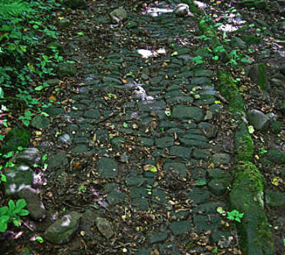
Below is a photograph of such a Hertfordshire minor Roman road as it appeared almost two millennia
after it had been adopted:
The ‘great’ (and undisputed) Roman roads of Hertfordshire
The discovery of Roman roads in Britain is an on-going process. An apparently definitive assessment
was Roman Roads in Britain (1903) by Thomas Codrington. This was superseded by ID Margary’s
exhaustive 546-page tome with the same title, the 1967 edition of which is referred to here.
Margary’s footnotes include copious references to volumes five and thirteen of the East Herts
Archaeological Society Transactions - but not the article in volume three which is quoted at the start
of this piece. Between 1955 and 1967, a detailed exploration of Roman roads in the south-east
Midlands by a group called Viatores revealed many new examples of minor Roman roads around
Bedford, Bletchley and St Albans. More additions to the catalogue of known Roman roads have been
made since 1967. Significantly, in view of the subject we are discussing, Margery wrote:
‘The inclusion of minor roads is always a difficult problem that can often be solved only by
consideration of evidence of alignment, relation to Roman occupied sites and constructional
details’
To illustrate the progress of research in this field, the Kimpton (six
miles south of Preston) History Group commented that “in the last ten
years archaeologists have discovered a network of minor Roman
roads, built for civil rather than military purposes.
“These roads often followed pre-Roman tracks….Three such routes
passed through Kimpton: ST. ALBANS - ICKLEFORD near HITCHIN,
via edge of Gustard Wood Common - Kimpton Hall Farm - Kimpton
Memorial Hall - Cuckolds Cross.COLEMAN GREEN (Near
SANDRIDGE) - BALDOCK, via rear of Ayot St. Lawrence Church -
spine of hill down to Kimpton Mill (called Laver Street) AYOTBURY
(Near WELWYN) - FRIARS WASH, via the high ground to the north of
the Lea Valley, passing behind Cross Keys Public House - then
changing direction slightly to follow the now disused road which ran
up to 1874 from Blackmore End to Raisins Farm.”
Hall Lane, leading up
from Kimpton to Hall
Farm
Watling Street This most important road ran roughly north-west from the Kentish ports (including
Dover )to Wroxeter in Shropshire via Rochester, London, Brockley Hill (near Stanmore, North
London) then NNW to St Albans and Dunstable.
Ermine Street This via was the second most important Roman road and was laid approximately due
north and directly connected London and Lincoln. It’s route is largely duplicated by the A10 to
Royston, Herts where it crosses the Icknield Way. Thus, it was nearer Ware than Hertford and ran
north through Hertford Heath, Thundridge and Buntingford, (the latter being around eleven miles due
east of Hitchin) and thence Braughing (where there was a Roman settlement making this an
important junction).
Ware was a hub of roads, with one running from St Albans and another to Baldock where another
road linked with St Albans.
Icknield Way This Way may well be the oldest road in Britain, extending from the Dorset coast to
Norfolk. It was thought to have pre-dated the Roman occupation, although recently this has been
questioned. From Toddington to the north of Dunstable it ran about five miles north of Luton and three
miles north of Hitchin (near Ickleford), continuing on to Royston.
Other Roman roads in Hertfordshire: One led north-east from St Albans near Sandridge, Coleman
Green and Waterend towards Welwyn and then on to the settlement at Braughing. It joined Ermine
Street at Colliers End.
Another road ran from London via Hatfield to Stevenage, Herts. Traces of this road have been seen
at Alexandra Palace, Muswell Hill, Brookmans Park, Hatfield Park, Welwyn Garden City to Digswell
water and then Woolmer Green, Knebworth and Stevenage - where it met a road that ran from
Baldock to Coleman Green (for St Albans). This latter route at Braughing had a junction with the next
road to be mentioned and passed Lammas Wood, Ayot St Lawrence, crossing the River Mimram by
Kimpton Mill, and thence to the Codicote-Wheathampstead road and Coleman Green.
A secondary road went from Braughing to Baldock and Godmanchester. At Baldock, it joined roads
from St Albans and Welwyn and crossed the Ichnield Way.
Three of the great Roman roads ran through Hertfordshire - Watling Street, Ermine Street
and the Icknield Way. In addition, other roads centred on St Albans (Verulamium).
Did a minor Roman road traverse Preston?
After this lengthy preamble, we return to the nub of this article, did a Roman road pass through what
became Preston?
The argument against:
1) I have found only one reference to this road - in the East Herts Archaeological Society
Transactions of 1905 - as detailed in the opening paragraphs above.
2) In The History of Tewin (2009), there is no mention of a Roman road (and no other evidence of
Roman occupation of the village) in the vicinity of Tewin as highlighted by RT Andrews. I feel sure that
if there was the merest suggestion of a road passing through Tewin, it would have been grasped with
eagerness by its historians.
3) Few, if any, Roman finds have been made in Preston, to my knowledge…..
The argument for:
1) ID Margary’s Roman Roads in Britain makes several references to articles in volumes of the East
Herts Archaeological Society Transactions. It is inconsistent to do this and not reference RT Andrews’
piece which was also in their work. However, if it may not have been found by Margary as it was not
obvious by its title that the paper mentioned Roman roads.
2) RT Andrews (1838 - 1928) was an antiquarian, architect, surveyor and author of a bibliography of
Ware, who founded the East Herts Archaeological Society and, with his brother, also founded
Hertford Museum of which he was a curator - so, some impressive credentials!
3) Andrews’ piece mentions a Roman road at Kimpton Mill, the existence of which is accepted. This
perhaps adds credence to his other comments.
4) If this Roman road existed, it should not come as a surprise as it has been written that another
Roman road passed near Preston following some of path of the St Albans Highway, to the south of
the village. Roman Roads in the South East Midlands (1964) traces its path: “…At the southern
boundary hedge of the grounds of Stagenhoe, a field-gate is on the line and inside the gate to the
north, a low agger (a Roman-built embankment or elevation that provided a draining base to the road)
is visible for twenty-five yards the the point where the present lane, which marks the course of the
eighteenth century St Albans to Hitchin road, swings off in a wide curve to the west, first a track and
then as a hollow way.
The line of the Roman road goes straight on ……until the eighteenth century road joins it from the
east. From this junction for a quarter of a mile to the north edge of the wood, the eighteenth century
road, now a wide hollow way, marks the course as far as the modern St Pauls Walden to Preston
road on the hill by Hitchwood Cottages. Northward, up the hill from the cottages, the agger twelve
feet wide is to be seen for 100 yards on the west side of the modern road. At the gate lodge of
Temple Dinsley the modern road following the line of the eighteenth century St Albans Highway,
which name is still in use locally, diverges eastward in a deep cutting, but the Roman road goes on
due northward, following the natural shoulder of the (land).” So, there was certainly known Roman
activity and transportation very close to Preston and another via close-by would not be a leap of faith.
My comments: Hitch Wood would have been far more extensive in Roman times - and even today
there are a number of paths criss-crossing the forest. No mention is made of how close to Temple
Dinsley the road ran; just that the road was to the south-west of Temple Dinsley. The most obvious
route of the road would be, after cutting through Hitch Wood, to follow Preston Hill Farm Road, Back
Lane, Butchers Lane and then the Charlton Road to Offley Holes. But this is pure conjecture.
Alignment: Let us use the Margary’s yardstick of how to identify Roman roads: “…consideration of
evidence of (1) alignment (and) (2) relation to Roman occupied sites”. This was what Andrews wrote:
‘…another of these Romanised British ways commenced on the line of Ermine Street, near
Ware…ran on to Hertford….then it went along the North Road to just beyond the Hertford General
Infirmary…From this spot such a way as this can be traced almost continuously by roads and
footpaths (for many of the footpaths are often much older than the contiguous roads) onward for
several miles….(through) Tewin…the south side of Knebworth Park and by Graffridge Wood, then on
to St Pauls Walden Church, Hitch Wood and the south-west side of Temple Dinsley, and so by
Hunsden House (aka Castle Farm) and Offley Holes to a point two miles west of Hitchin; here it
crossed the Icknield Way half a mile east of Highdown and so on to the west of Pirton Church to
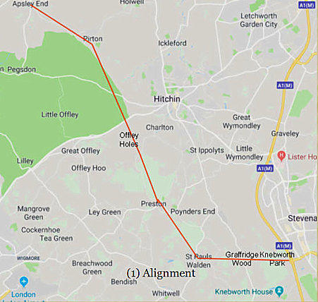
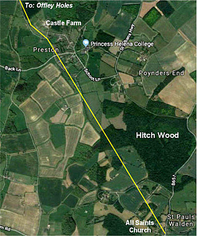
Apsley End…’ The approximate route from Knebworth Park is shown below:
Relation to Roman occupied sites: Apsley End is a close neighbour of the Bedfordshire village of
Shillington - which was created from a number of villages whose names ended in ‘End’. The following
is an abbrieviated version of comments made about the history of Shillington,
“The Bedfordshire Historic Environment Record” [HER] contains information on the county's historic
buildings and landscapes and summaries of each entry can now be found online as part of the
Heritage Gateway website. There is quite considerable evidence for Romano-British activity in the
modern parish of Shillington.
The Viatores are a group who are dedicated to trying to discover Roman roads in the modern
landscape. There is a possible Roman road in Shillington [HER 10472], evidence having been found
outside 52 High Road. This consisted of an old road surface four inches below current by builders in
June 1959. The orientation seems to have been north-south or, perhaps, north-west to south-east.
The surface included metalling with pebbles on the grey clay subsoil. The road was certainly in use in
the late Middle Aged as sides of a 15th century leather shoe were found.” (Then followed an
impressive and lengthy list of Roman finds in the vicinity)”
The amount of Roman material found in Shillington, particularly the huge number of coins, is very
surprising for an area which, before the late 20th century, had no obvious Roman associations such
as a major road (like Watling Street) or Roman town”. However, most if not all of these finds were
made after Andrews’ comment in 1905. In view of this, one might ask ‘Why did Andrews select Apsley
End as the destination of this road’; ‘How and why did he decide on the course of this road - which
included Preston. Was it simply by following a (fairly) direct line of roads, lanes and footpaths from
maps.’ There is so much we do not know about the background to his claim and without this
information, it is difficult to make a judgement call on his view.
If there was a Roman road through Preston, what course might it have followed?
In December 2019, Keith Fitzpatrick-Matthews (Hitchin Museum Curator and Heritage Access
Officer) kindly provided these comments:
“Re: Roman roads “I’d be very wary of accepting Margary’s ‘minor roads’ in our part of the world and
even more wary of R T Andrews’ speculations (in his time, the criteria for establishing what was
significant or not in the Roman period were much looser than we would accept today).
Most of Margary’s local minor roads are based on the work of a group of the Viatores, who worked in
the 1950s and early 1960s, as you point out. They were very enthusiastic and published a book
detailing a dense network of roads in the south-east Midlands. During the 1980s, archaeologists
working for Bedfordshire County Council decided to investigate how many of the new roads they
had identified were really Roman, as they were worried that the majority did not seem to link
important places in the Roman period.
The critique, published by Angela Simco, was devastating: not one of the ‘new’ roads could be
shown to be Roman; some were demonstrably new at the time of Enclosure in the late eighteenth or
early nineteenth century; some were just lines on a map with nothing on or under the ground to
suggest that there had ever been anything there.
The discovery of Roman finds (such as coins or pottery) is no guarantee that a constructed road ran
through an area; it is very rare to find a field in which Roman coins or potsherds cannot be found!
Irritatingly, there is currently no published LIDAR coverage for the area in which your suggested
road runs, so it cannot be checked using this technique.
I’ve looked at the historical imagery in Google Earth, which doesn’t show any soil or parch marks
that would indicate a Roman road on the line, but that is far from conclusive in a negative sense.
Roman roads are a real minefield, as the experience of the Viatores shows: unless you have
conclusive excavated evidence, backed up with aerial photographs and/or LIDAR, speculation about
routes is nothing more than that, so caveat viator!”
The proximity of this ‘via’ to the extensive Roman fortress at Caerleon adds to the possibility of ‘our’
road being indeed Roman. However, in around the year 2000 a survey of the road was arranged by a
local community council. Its conclusion to the disappointment of many was that the road was too
modern to be Roman. Yet it is still called “The Roman Road”.
This report is dated 1999 and appears to divide the one road mentioned below into three roads. (The
details that follow have been mostly extracted from ID Margary’s Roman Roads in Britain [1967
edition] )
An alternative view
To a layman, such conflicting views by qualified scholars about Roman roads are confusing.
There is little information about Dinsley, Preston and their environs before the Domesday Survey of
1086 - however, an article by RT Andrews in the East Herts Archaeological Society Transactions
Vol 3 Part 1 (1905 ) postulates that there was a Roman road that traversed Preston.
Comments on a Roman road near Preston by local historian, Nina Freebody
I recently came across some notes by Preston historian, Nina Freebody, which I believe were part of
a slide show presentation she gave re: Stagenhoe.
She wrote, ‘…a minor Roman road runs from St Albans and Kimpton, then by Nine Springs through
the (Stagenhoe) estate cutting just to the west of Stagenhoe Gardens, passing Pinfold Wood,
Hitchwood Cottages and along the road with the Preston stud on the left towards St Ippollitts. It is still
called St Albans Highway.’ She gives no references for this statement.